
Mt Sonder & Redbank Gorge
- Adventuress
- May 22, 2021
- 3 min read
Majestic mountains split by steep canyons, hidden waterholes, prolific birdlife and views view views.

I loved being in the West McDonnell Ranges!!!.
I highly recommend the trek up Mt Sonder for those with moderate level of fitness.

Rugged raw rock
Mt Sonder stands
proud & strong against the skyline. Rough rugged raw rock that really draws your eye, and your feet to climb it.
Or perhaps it is that my eyes are still enjoying the novelty of mountains after having spent a few months in the very very flat outback of South West Queensland.
But first, where is Mt Sonder?
The image below shows the route I have taken to get to this point since leaving Noosa 5 months ago.
Noosa - St George - Cameron Corner - Innamincka - Birdsville - Maree - Oodnadatta - Dalhousie Springs - Uluru - Kings Canyon and into the West McDonnell Ranges where I was at the time of writing

This next picture, a screen shot captured from Google Earth, shows the terrain of the West McDonnell Ranges, with Alice Springs shown to help you understand where Mt Sonder is.

For more information try here: Mt Sonder: Wikipedia
Mt Sonder - 4th highest mountain in the Northern Territory
Red Bank Gorge and Mt Sonder are amongst the first of the 'tourist must-do's' that you will come to if you are travelling into the ranges from the West: only 133kms west of Alice Springs.
The trail guides recommend allowing 6-8 hours for the return walk up & down Mt Sonder.
Distance 15.8km Altitude max 1280m Duration 6 hours Trail type Return

I was super stoked to get to the top with relative ease in 2.5 hours.
Total return time for me was just under 4 hours (which included all the time I spent chatting to other walkers on the trail).
I found going down more challenging that going up.


Spot the lizard in the image below:


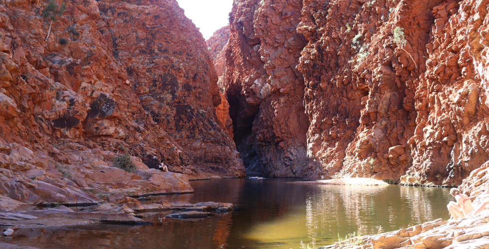
Redbank Gorge
Access to Red bank Gorge is via a
mostly-level trail up/alongside the dry (while I was there) river bed from the waterhole.
Very useful information here: Redbank Gorge factsheet
The water is very very cold in the waterhole as the sun does not penetrate the steep sheer sides of the gorge long enough to heat it.
There are plenty of signs warning you to take care to avoid spending too long in the water as it is so cold you can get hypothermia easily.


I consider myself quite hardy, but there was absolutely no way I was going to swim up into the narrow section, it was quite simply too cold for that.
I watched as a young adventurous traveler arrived at the gorge with an inflatable Lillo purchased for the sole purpose of using it to explore the narrow gorge while staying mostly out of the water. We watched has he inflated the Lillo puff at a time, before setting off into the water and up the narrow crack between the walls of the gorge..... a few mins later we could hear the plastic squeaking noise of the Lillo against the rock as he tried to force the Lillo up through the narrow slit of the canyon!
In hindsight I was very pleased that I walked up Mount Sonder before heading to the waterhole, at least I was warm and desperate to cool down when I got into the water. But even then it was a challenge, the water was so cold.


I was super stoked at the end of the day to find a sweet camping spot at the Finke 2 Mile spot - a free camping spot on the dry river bed beside water holes of Finke 2 Mile Creek.
The spot was so nice I spent 2 nights camping beside and swimming in the waterhole.

Video - of course there is a video.... here it is:
Comments